
“All freeways (in LA) were built not just on top of water, but from the history of water”
–Charles Hood, A Salad Only The Devil Would Eat
Do you ever wonder where all the water is in LA? In many cases we are driving on top of it. If you’ve been on the 110 freeway between Downtown and Pasadena and, navigated the meandering curves while catching a quick glimpse of some water in a concrete channel off to the passenger side of your car? Well that’s because this stretch of road, considered America’s first freeway, is in an actual streambed.
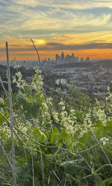
Downtown LA from Deb’s Park with California Cucumber, a native plant, in the foreground and the Arroyo Seco alongside the 110 Freeway below. Photo by Amanda Smith
Other places with hints of water: maybe you’ve been on a bike ride around the Rose Bowl, to a swim meet at the Aquatic Center, or to hang out in the Brookside Park? And just across the road you saw a concrete channel and thought, “that’s probably just a storm drain”. Or maybe you went to an open house at NASA’s Jet Propulsion Laboratory and on your way there wondered what that big sandy wash beyond the research facility was? Or maybe you drove up HWY 2 with some friends and had a nice shady hike at Switzers Falls?
It turns out all of these places are connected by a watershed, a creek called the Arroyo Seco. This stream is a tributary of the Los Angeles River (a tributary is a stream or smaller river that flows into a larger river) and like many watersheds in LA a large portion of it was contained in a concrete channel in the 1930’s. The Army Corps of Engineers did this so that development could encroach right up to its banks without the threat of flooding. Despite the concrete, tributaries like the Arroyo Seco remain critical for the health of local wildlife, our aquifers, the LA River, and us.
However, citywide this important waterway remains mostly unknown. There are other tributaries of the LA River too, the Tujunga Wash, Rio Hondo, Verdugo Wash, Aliso Creek, and they all play a critical role providing places for city dwellers to recreate and spend time with water. Getting to spend time with water is important because studies show that these “blue spaces” can provide even more mental health benefits than just park space alone.
So how can you get to know the Arroyo Seco? Read about these stops along the Arroyo that will get you close to water, plants, and wildlife in the city and in our local mountains.
Switzer Falls Day Hike
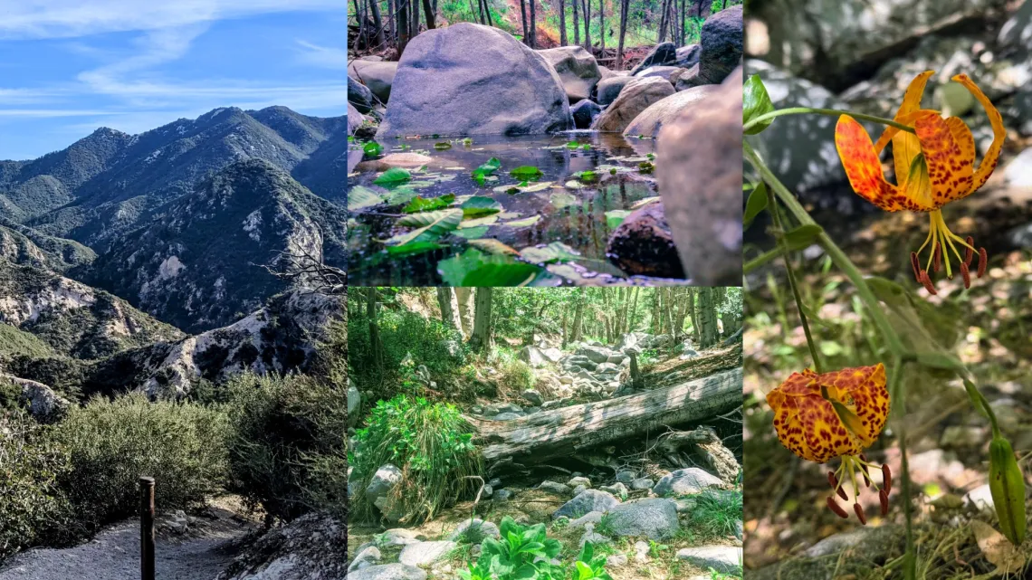
Switzer Falls. Photos by Amanda Smith
Known today as Switzer Falls, named after a premier wilderness camp founded by Commodore Perry Switzer in 1884, this area has been and is home for the Tongva people since time immemorial. Today it is also a popular day hike for Angelinos looking to get out of the city by taking HWY 2 up into the Angeles National Forest. Despite the popularity of this day hike, many people I talk to are surprised to know that this area is the headwaters for the Arroyo Seco, a name many might associate only with the concrete channels down below. The wildness of Switzer Falls feels a world away from the city but making the connection that our waterways are wild streams is crucial for Angelinos to understand and care for our local water. LA is a wild place! Here you can find Tiger Lillies, Newts, and many more of the thousands of native species that call LA County home.
Switzer Falls is a 35-minute car ride from Downtown LA or look for group hikes that might be carpooling up HWY 2. In the works is the Mt. Wilson Express, a collaboration between the City of Pasadena, Nature for All, and the U.S. Forest Service. Contact lanatureforall.org to learn more about this new initiative and for other ways to access our local mountains without a car.
Hahamongna Watershed Park
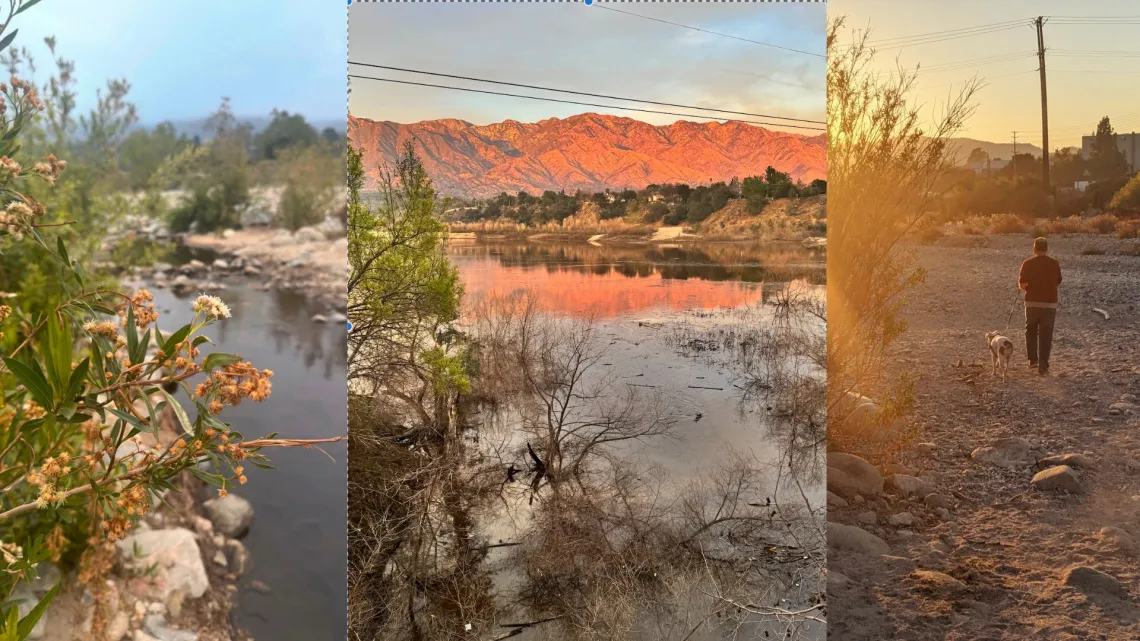
Photos from left to right: Mulefat (a native plant) and the Arroyo Seco, The San Gabriel Mounains and Devils Gate Resevoir at sunset, and a walk across the wash in drier times. Photos by Amanda Smith
Only 5% of California’s alluvial scrub habitat is left in California but you can experience one of the last alluvial washes left in LA county in this urban-wildland interface. Enjoy this rare habitat all while peering into NASA’s Jet Propulsion Laboratory, sharing the trail with horses from the Rose Bowl Riders stables, or watching out for frisbees from Oak Grove Disc Golf, widely considered to be the world’s first disc golf course (it was built in 1975).
Here is where the Arroyo Seco exits the San Gabriels mountains and is actually allowed to meander freely for a short stretch through a sandy wash before it collects behind Devils Gate Dam (which has its own storied lore like occultist believing it is one of the Seven Gates To Hell and many supposed UFO sightings). Water is diverted here for ponds that help recharge the Raymond Basin Aquifer which provides groundwater to Pasadena.
You can walk through the wash as a loop trail or go into the canyon towards Brown Mountain Dam (which is being researched for potential removal, follow @arroyosecofoundation to learn more). In both directions this area has so much to give. There are bird walks with Pasadena Audubon (@pasadenaaudubon) and make sure to make your own super bloom at home by visiting the Hahamongna Native Plant Nursery (@hahamongnanursery on Instagram) found near the horse stables.
This area holds significance for the Tongva people of LA and the area is now named for the local band of Tongva, the Hahamog’na,a name which means flowing water, fruitful valley.
The closest public transportation to this area is to take the Metro A Line to the Memorial Park Station. The park is still 3-4 miles from this metro stop, either bring a bike, use a rideshare app, or use the LA Metro Trip Planner or Pasadena Transit App to find local bus schedules.
Colorado Street Bridge to South Pas Nature Park
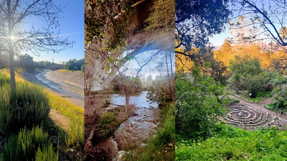
Photos from left to right: The Arroyo with riverrock lining the channel walls, the restored stretch of Arroyo under the Colorado and the 134 bridges, a labyrinth at the South Pasadena Nature Park just beyond the golf course. Photos by Amanda Smith.
The Arroyo Seco passes by so many famous landmarks on its way to meet the LA River in Lincoln Heights and in the Lower Arroyo park it humbly passes by the Rose Bowl, built in 1922, which now sits in the stream’s original flood plain.
Once past the Rose Bowl the Arroyo passes through a more natural stretch with a soft bottom and lots of plants while passing under the world famous Colorado St Bridge. Built in 1913 the bridge has elegant Beaux-Arts arches and at the time was the world’s tallest concrete bridge.
After the Arroyo was declared a Pasadena Cultural Landmark in 1977 work was started to preserve and restore this area that had been mostly used as a gravel mine since the early 1900’s (gravel from stream beds is often used for concrete and roads… again we are driving on the rivers as Charls Hood says in the opening quote). The work to create the Lower Arroyo Park into a multi-use park took until 2005 and restoration of native plants and ecosystems continues to this day.
San Pascuel Stables, the Lower Arroyo Archery Range managed by the Pasadena Roving Archers, and the Pasadena Casting Pond (one of only three fly fishing casting ponds in the state) are also highlights of this stretch.
The true gem of this area is The South Pasadena Nature Park, a 3 acre park lovingly cared for by a committed group of volunteers and non-profits. Go to @southpasnaturepark on Instagram to learn more.
Take the Metro A Line to South Pasadena Station, then it’s about a 15-minute walk west to the park. Metro Bus 258 stops nearby on Pasadena Ave/Mission St, which cuts down the walk and the South Pasadena DASH also serves the area. The Lower Arroyo does not have paved paths but they are wide and mostly flat for bikes that can handle dirt. A paved stretch of bike path goes for several miles from Marmion Way to the Montecito Heights Recreation Center.
Sycamore Grove Park/ Debs Park
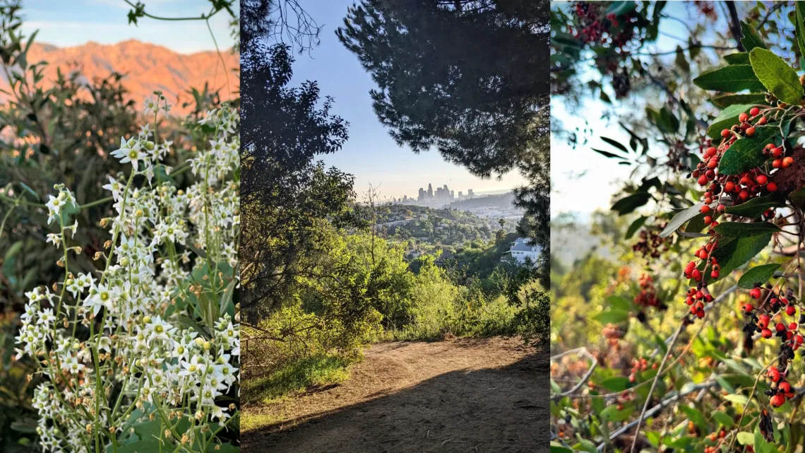
Photos from left to right- California Cucumber with San Gabriel Mountains, Downtown LA from the top of Debs Park, Toyon with berries near the Audubon Center at Deb’s Park. Photos by Amanda Smith
Even when I talk to Angelinos who have heard of the Arroyo Seco, most associate it with Pasadena. But the Arroyo provides critical blue space for Northeast Los Angeles too. Neighborhoods like Highland Park, Hermon, Montecito Heights, Cypress Park, and Lincoln Heights are all connected to the Arroyo as well.
Sycamore Grove Park and Deb’s Park are two great ways to enjoy the Arroyo Seco in Northeast LA. Sycamore Grove with its bandshell, picnic tables, and event hall is a great place to get to know the Arroyo. It used to have its own natural stream called the North Branch which flowed for 6 miles through what is now Highland Park before meeting the Arroyo Seco where Sycamore Grove Park is now. It was put into a concrete tunnel (culvert) beneath the park in the 1930’s. Northeast LA was full of water fed by natural springs, including the prominent Glenn Rock Spring. Something to ponder while spending time here.
Across the stream are more park facilities with basketball hoops, tennis and pickleball courts, a playground, and baseball fields connected by a pedestrian bridge. And if this all wasn’t enough, Debs Park, one of LA’s largest municipal parks has 282 acres available for hiking, birdwatching, and even fishing at a hilltop pond.
This is the home of an Audubon Center at Debs Park, a community driven center that was the first from this organization to focus on an urban area. You can also buy California Native Plants here at the new Los Nogales Nursery from Friday to Sunday. Follow @audubon_debspark and @theodorepayne to learn more
This area is the easiest to get to by public transportation out of the four areas mentioned here. Metro Bus 81 runs along Figueroa Street and stops right at the park (Figueroa/Sycamore Grove Park stop). You can also take the Metro A Line to Highland Park Station and walk south along Figueroa — it’s a short walk.
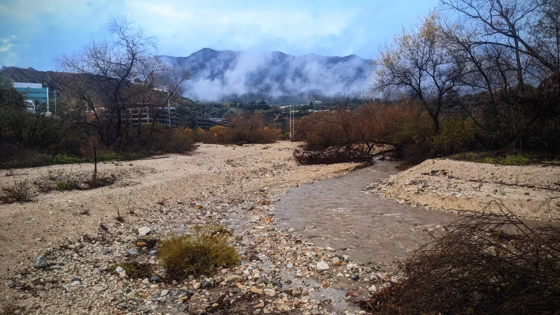
Photo by Amanda Smith
So get out there and get to know this cultural landmark and spend time with water right here in the city. The Arroyo Seco is my favorite stream in all of LA. It helped me see that there is water in here, it’s just that sometimes we are driving right over it without even noticing.
But, once you start paying attention, you will see the signs of water all over town. Connecting to local water has so many benefits. How has the Arroyo Seco changed your life?
Amanda Leigh Smith is a California Naturalist and artist based in Los Angeles. You can find her work on www.losangelesisnotadesert.com or on Instagram @laisnotadesert